About IGN maps (E-walk plugin)
E-WALK PLUGIN This app in an E-walk plugin (a plugin is an app that adds features to another app). You need E-walk to use this plugin: https://play.google.com/store/apps/details?id=com.at.ewalk.free . The plugin adds to...
E-WALK PLUGIN
This app in an E-walk plugin (a plugin is an app that adds features to another app). You need E-walk to use this plugin: https://play.google.com/store/apps/details?id=com.at.ewalk.free .
The plugin adds to E-walk the ability to use the French IGN maps, and IGNrando'.
WARNING: these features mostly cover France only.
IGN MAPS
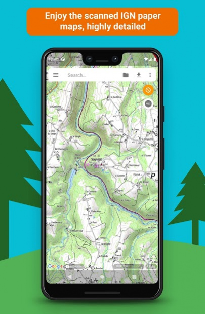
The IGN maps are highly detailed and cover the totality of french territory. Some maps are only available at certain zoom levels. They are the same as the ones used on the Géoportail website (http://www.geoportail.gouv.fr).
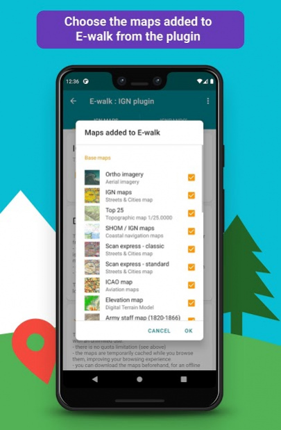
The IGN maps plugin adds to E-walk 8 base maps :
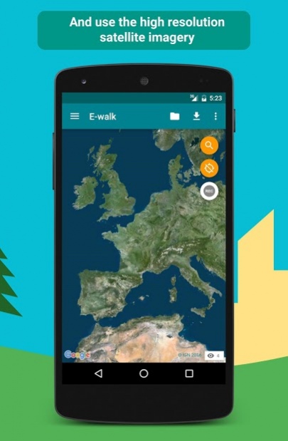
• ortho images: a high resolution satellite imagery (zoom levels 2 - 19)
• scan: a scan of paper IGN maps (zoom levels 2 - 18)
• scan express (classic): a scan of paper IGN maps often updated but with less details (zoom levels 6 - 18)
• scan express (standard): a scan of paper IGN maps often updated but with less details, with another style (zoom levels 6 - 18)
• ICAO maps: International Civil Aviation Organisation maps (zoom levels 6 - 11)
• administratives limits: administratives limits map (zoom levels 6 - 10)
• elevation map: digital terrain model (zoom levels 6 - 14)
• army staff map (1820-1866): historical map from 18th century (zoom levels 6 - 15)
And 8 overlay maps:
• cadastral parcels (black): map of numerical cadastral information (zoom levels 2 - 20)
• cadastral parcels (white): map of numerical cadastral information (zoom levels 2 - 20)
• cadastral parcels (orange): map of numerical cadastral information (zoom levels 2 - 20)
• administrative limits: map of administrative limits (zoom levels 6 - 18)
• buildings: map of constructions (zoom levels 12 - 18)
• geographical names: map showing names of cities, towns, etc... (zoom levels 12 - 18)
• Histolitt coastline: map showing the limit between land and marine area (zoom levels 6 - 18)
• hydrography: map of lakes, reservoirs, rivers, creeks, etc... (zoom levels 6 - 18)
LICENCES
The plugin allows to see the maps through two licences: Discovery licence (free), and Adventure licence (5.99$USD / month or 14.99$USD / year). The Discovery licence is limited by a monthly quota shared between all the users. Once the quota is exceeded, the maps can't be displayed until the next month.
With the Adventure licence, you can also download the maps beforehand on your device, in order to use them without any internet access.
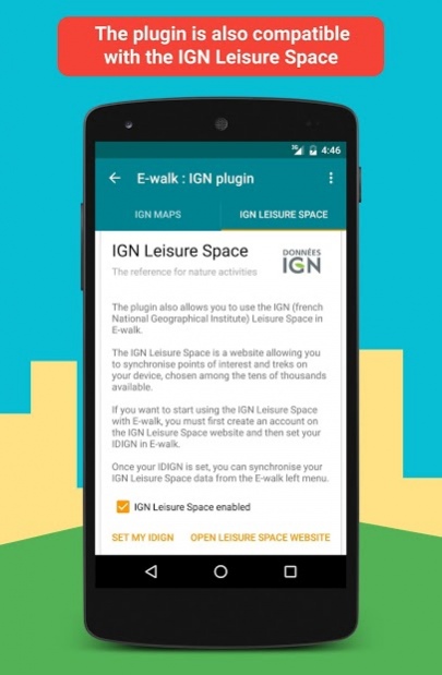
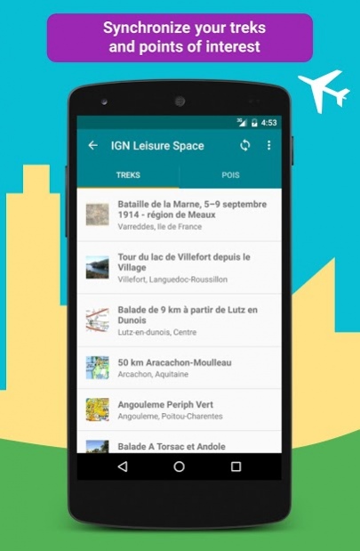
IGNrando’
IGNrando' (https://ignrando.fr) is a website provided by the IGN, allowing you to visualize treks and points of interest among the tens of thousands available. You can also add and share yours. Those treks and points of interest are mostly available in France only.
With E-walk, you can synchronize the treks and points of interest that you like on your device. Thereby, they will be available anywhere, and you'll no longer need an internet access to see them.
Previous Versions
Here you can find the changelog of IGN maps (E-walk plugin) since it was posted on our website on 2016-10-30 00:21:12.
The latest version is 1.0.30 and it was updated on 2024-04-22 10:59:26. See below the changes in each version.
IGN maps (E-walk plugin) version 1.0.30
Updated At: 2021-07-14
Changes: Added support for E-walk 1.4.0.
IGN maps (E-walk plugin) version 1.0.28
Updated At: 2020-09-14
Changes: This release fixes some bugs.
IGN maps (E-walk plugin) version 1.0.22
Updated At: 2020-05-21
Changes: Bug fixes.
IGN maps (E-walk plugin) version 1.0.21.beta02
Updated At: 2020-05-15
Changes: This update adds historic 1950 IGN maps, fixes some bugs and adds compatibility with E-walk 1.3.0 .
IGN maps (E-walk plugin) version 1.0.20
Updated At: 2020-02-22
Changes: This updates adds compatibility with E-walk 1.2.0.
IGN maps (E-walk plugin) version 1.0.19
Updated At: 2019-12-07
Changes: This update fixes a bug crashing the app when clicking on an IGNrando' trek.
IGN maps (E-walk plugin) version 1.0.18
Updated At: 2019-11-13
Changes: This update fixes a bug make communication IGNrando' not working on some devices.
It also adds compatibility to version 1.1.5 of E-walk (to support map previews).
IGN maps (E-walk plugin) version 1.0.17
Updated At: 2019-08-29
Changes: This update fixes a download bug when using the Top25 layer and another one when uploading a trek to IGNrando'. It also adds two new layers: a base map for coastal navigation and a slope overlay map.
IGN maps (E-walk plugin) version 1.0.3
Updated At: 2016-05-30
Changes: This update adds support for the IGN Leisure Space! The IGN Leisure Space is a website allowing you to synchronise points of interest and treks on your device, chosen among the tens of thousands available: http://espaceloisirs.ign.fr,WARNING: You need E-walk 1.0.15 (or newer) to use the IGN Leisure Space.,The update also fixes some minor displaying bugs.
Disclaimer
External Download
We do not host IGN maps (E-walk plugin) on our servers. We did not scan it for viruses, adware, spyware or other type of malware. This app is hosted by Galad and passed their terms and conditions to be listed there. We recommend caution when installing it.
The APK Download link for IGN maps (E-walk plugin) is provided to you by apps112.com without any warranties, representations or guarantees of any kind, so access it at your own risk.
If you have questions regarding this particular app contact the publisher directly. For questions about the functionalities of apps112.com contact us.